The SCORE Information and Communications Technology Platform (SIP) is now ready to be used by the project partners to store all the knowledge about Ecosystem-based Approaches (EbA) collected during the course of the project.
This platform was design and developed by UNIPI and TERO as part of their activities in Work Package 5 on “Pre/post-EBA Interventions Evidence Collection and Knowledge Marketplace” (under Task 5.3 “Development and Management of the ICT Platform” in the project’s workplan).
This high-quality platform aims to ensure the long-term storage of data related to EBA (Ecosystem-based Adaptation) solutions. These are heterogeneous data, consisting, for instance, of georeferenced GIS (Geographic Information System) maps, charts, datasets, tables, and documents. They refer to both the implementation of the proposed nature-based intervention together with the relevant cost evaluation, and the assessment of the pre- and post-EbA impact of coastal erosion on hazard, risk and socio-economic parameters. Therefore, the platform represents an efficient tool for sharing knowledge on EBAs. Data gathered by the project partners were already made available of this platform and will be continuously fed throughout the project by the partners. In addition, the platform is complemented by an Application Programming Interface (API) that allows it to exchange data and link with other environmental databases.
The first working version (also termed “beta” version) of the SIP was released in December 2022 as the project’s deliverable D5.3 “SCORE ICT Platform, 1st version”. This deliverable consists of the SIP, featuring the SCORE database that shall collect and share all the project data, together with the relevant interfaces toward the Coastal City Living Lab (CCLL) sensors, the Graphical User Interface (GUI), documentation, and manuals.
Next steps
During the first half of 2023, the “beta” version of the platform will be thoroughly tested. Therefore, in this time interval, the access will be restricted and project partners only will be allowed to use the platform. After, at the end of the testing phase (milestone MS7, in June 2023, at mid-project) a complete, working, and open version of the SIP will be issued and made freely accessible worldwide in consultation in order to share project results with the scientific community, but also with governments, institutions, administrations, schools and the general public. In this way, the SCORE platform will eventually attain its ultimate goal and will become a pre/post-EbA interventions evidence collection and knowledge marketplace.
At the end of the project (June 2025), a final version of the SIP will be made available (as Deliverable D5.7).
Technical settings
The SIP is a stack of front-end and back-end services, running as a server application with HTTP interfaces and a web client application. The platform consists of the following two macro-subsystems which run independent services:
- Data Hub – Developed using GeoNode[1] and GeoServer[2], it includes the SCORE database which will host all the project data, plus the relevant services (metadata, spatial data, etc.) and interfaces (GUI, etc.); it also provides the data management services, the data and metadata catalogue, the client applications and the APIs to access and manage the catalogue.
- Sensor Service – Developed by the Fraunhofer Institute of Optronics, System Technologies and Image Exploitation, based on the FROST Server[3]. The Sensor Service is dedicated to collection, cataloging and publishing of sensors and sensors data.
The Data Hub collects information from the Sensor Service and exposes the list of sensors inside the data catalogue, along with other resources directly managed by the Data Hub itself.
Remarkable features of the SCORE ICT Platform
The newly developed SIP offers a certain number of remarkable features as it:
- Aggregates geospatial, documentary, and multimedia contents from multiple channels: direct input by users, push channels via REST API, and pull via a pluggable harvesting engine;
- Enriches the data that feed the platform with metadata, according to standard formats (Dublin Core, ISO, etc.) and published both on standard OGC services and via REST API;
- Offers visual tools for creating maps, dashboards and geostories based on the catalog of data and documents. These representations, in addition to being published on the platform itself, can be inserted into external web pages and portals;
- Allows a granular management of access rules to content and services, supported by multiple options for user authentication;
- Is an open source software which can be used without license fees, freely analyzed for quality and safety checks, and extended and modified by anyone;
- Is actively developed and employed in a large variety of scenarios, both public and private. The long list of national and international bodies and organizations that have adopted it includes, among the others, the UN, UNESCO, FAO and the World Bank.
-
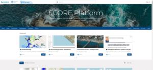
- SIP landing page
-
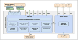
- SIP high level architecture
[1] GeoNode (https://geonode.org) is a web-based application and platform for developing geospatial information systems (GIS) and for deploying spatial data infrastructures (SDI).
[2] GeoServer (https://geoserver.org) is an open source server for sharing geospatial data and designed for interoperability. It publishes data from any major spatial data source using open standards and implements industry standard OGC (Open Geospatial Consortium) protocols.
[3] FROST (https://www.iosb.fraunhofer.de) is a server implementing the OGC SOS and STA protocols to store and query real-time sensor data and sensor data time series. The offered sensor data consists of data directly from the sensors, which are encoded in special formats. The web service as well as file formats are open standards and specifications defined by the OGC (Open Geospatial Consortium).