One of the key activities of the SCORE project is to map the baseline exposure and risk of extreme climate impact of coastal cities. This work is carried out in Work Package 1 (WP1) which main objective is to produce a high-level baseline risk map of extreme climate impacts and sea-level rise for the ten Coastal City Living Labs.
WP1 is divided in four sub-tasks, that each produce a deliverable: the literature review report, the map and report of key climate change hazards, the map and report of baseline exposure and vulnerability, and the map and report of baseline risk analysis. So far, the SCORE Team has been working on the first two. The literature review was completed in December 2021, and the second deliverable was completed during Summer 2022. Currently, as the final goal of WP1 is to produce a high-level risk assessment, we are working on the production of exposure and vulnerability indicators.
How do we assess vulnerability to climate change?
There is a number of tools used to assess vulnerability to climate change in coastal areas. The European Environment Agency summarised these in the technical paper Methods for assessing coastal vulnerability to climate change (2011) (EEA). The most relevant assessment methods include index-based methods, indicator-based approaches, methods based on dynamic computer models, and GIS-based Decision Support Systems. Each method has its own strengths and limitations, depending on the different aspects taken into consideration in the assessment. For example, time and spatial scale, resolution, the drivers or impacts analysed, the availability of data, the complexity or even the desired outputs.
Indicators or index-based approaches are useful tools for a baseline assessment and the identification of priority vulnerable areas and systems due to their simplified approach. On the other hand, the methods based on dynamic computer models and GIS-based Decision Support Systems are more appropriate for a more detailed quantitative assessment of vulnerability and the identification of adaptation measures.
Index-based approaches express coastal vulnerability by a risk/vulnerability index. This index is calculated through the quantitative or semi-quantitative evaluation and combination of different variables. Conversely, indicator-based approaches express the vulnerability by a set of independent elements that characterise key coastal issues. These indicators are in some cases combined into a final summary indicator. Notwithstanding, it is of common practice to adapt existing methods to the necessities of a particular assessment.
The case of the SCORE project
In the case of the SCORE project, the Coastal City Living Labs face different climate-related hazards and impacts and, furthermore, there is a lack of available data for some of them. For this reason, we are applying a bespoke semiquantitative approach based on a combination of popular index-based and indicators methods. Essentially, the methodology is developed to adapt to the available information through existing indicators.
In particular, the assessment involves the evaluation of the three fundamental parameters of vulnerability: stresses, sensitivity and resilience. These are identified as key hazards (stresses); physical vulnerability, socioeconomic activity, social vulnerability and ecosystem vulnerability (sensitivity); and adaptive capacity (resilience) and measured in terms of indicators. The indicators are being evaluated numerically and classified in a low-medium-high exposure scale.
The results of this task will be publicly released in a report during 2023 as SCORE’s deliverable D1.3. All the project’s deliverables are uploaded on this page.
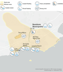
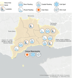
Below is a schematic representation of key climate-related hazards in Benidorm (Spain) and Oeiras (Portugal) CCLLs